


Calling on the “Dream Team,” Helping Lyndon Township make an important decision on Green Infrastructure
Local policies governing land use, in concert with land protection programs, help communities accommodate population and infrastructure growth while maintaining natural areas that provide critical ecosystem services and cultural benefits. Since 2005, HRWC has provided policy and technical support to local watershed governments to create Green Infrastructure Plans. Municipalities incorporate their Green Infrastructure map into their land use plans and policies, directing future development in a way that is in concert with their natural infrastructure. In the following article, Guest Author Sally Rutzky shares her experience as a Planning Commissioner with Lyndon Township working with HRWC Watershed Ecologist Kris Olsson. Lyndon Township is in western Washtenaw County and is home to more than 2600 people. This article is republished from our Spring 2024 Huron River Report, celebrating Kris’s retirement.
Creating a Green Infrastructure Map
When I was appointed to the Lyndon Township Planning Commission, I knew I needed to be trained from the ground up. I called the Huron River Watershed Council and asked for help. I saw a place for my ‘green’ point of view and wanted to make a positive contribution to my community. Kris gave me an entire afternoon and a lot to think about.
A little while later, Kris asked if she could hold a Green Infrastructure Workshop for our township. She met with the Planning Commission, the Board of Trustees, and residents. Lyndon Township is 51% state and county parkland, so we were attached to our lakes and woods in some way. We learned about environmental “hubs ” (intact natural lands that provide critical ecosystem services to the community)—half of our township was a giant ‘hub’! The result was a Green Infrastructure map which was displayed on the meeting room wall.
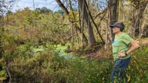
Conducting Natural Area Field Assessments
Months passed. In December 2013 the Planning Commission received an application for a special land use permit to develop a sand and gravel mine off M52 between the Waterloo and Pinckney State Recreation Areas and County Park Lyndon South.
I had been volunteering to do (natural areas field) assessments for property owners with Kris, and I asked if she could do a field assessment on the property proposed for the mine. She put together a dream team of volunteers which included Matt Heumann (Washtenaw County naturalist) and Tony Reznicek (University of Michigan botany professor and director of the University Herbarium).
Following the assessment, I took two other Planning Commission members on a site visit. Thanks to our dream team visit, I knew what I was showing them! We came back, tired and thirsty, to the township hall and sat down to rest in the meeting room. There on the wall was the Green Infrastructure map that we developed with Kris in our workshop. We looked to see where we had just been—the property was in the center of a hub created by the parks. It was so clear! We didn’t have to say a thing.
Protecting Key Natural Areas
Many people testified at two very large public hearings. There were hundreds of e-mails. Lawyers, professors, and engineers made presentations and wrote reports. A lot of work was done by many people. There was no public support for the proposed sand and gravel pit, that was clear. But in my mind, there was this indelible picture of the Green Infrastructure map behind all the discussions. In the end, the State of Michigan got involved, and the property is now part of the Pinckney State Recreation Area. Thank you, Kris.
—Sally Rutzky, Lyndon Township Planning Commissioner
HRWC asks you to please consider contributing to the Watershed Resilience Endowment Fund and join Kris’s fight for the protection of our watershed and river forever. Help us honor Kris’s thirty-one-year legacy as she retires from HRWC.