


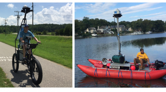
Huron River enthusiasts will soon be able to take a virtual interactive 360-degree tour of the entire river from the perspective of a paddler, including river access points, boat launches, portages and recreational amenities. Terrain360 will map the Huron River Water Trail July 14-16 from their custom-built pontoon boat with six cameras mounted 13 feet high. They will capture high resolution, panoramic, 360-degree images every 40-60 feet in a format similar to Google Street View for a result that puts visitors right into the outdoor places they love, like the Huron River.
The project is funded by the Southeast Michigan Council of Governments (SEMCOG) who has partnered with Terrain360 and several regional organizations, including HRWC, to map over 680 miles of Southeast Michigan land and water trails in Livingston, Macomb, Monroe, Oakland, St. Clair, Washtenaw, and Wayne counties.
Stay tuned for the final product! The virtual maps will be available on line at the Terrain360 website later this summer.
Land and water trails included in the project:
Water Trails
• Livingston/Oakland/Washtenaw/Wayne Counties: 140 miles of Huron River Water Trail
• Macomb County: 70 miles, including Clinton River Water Trail and Lake St. Clair Water Trail
• Monroe County: 44 miles of River Raisin Water Trail
• Oakland County: 41 miles of Clinton River Water Trail
• St. Clair County: 116 miles of Blueways of St. Clair
• Wayne County: 62 miles, including Detroit River Heritage Trail and Rouge River Water Trail
Hiking and biking trails
• Livingston County: 20 miles of Lakelands State Park Trail
• Macomb County: 36 miles, including Macomb Orchard Trail, Clinton River Park Trail, and River Bends Park Trail
• Monroe County: 14 miles, including River Raisin Heritage Trail, National Battlefield Park, and Sterling State Park Trails
• Oakland County: 55 miles, including Addison Oaks County Park and the Clinton River, Paint Creek, Polly Ann, and West Bloomfield Trails
• St. Clair County: 14 miles, including Blue Water River Walk in Port Huron and Wadhams to Avoca Trail
• Washtenaw County: 25 miles of Border-to-Border Trail
• Wayne County: 44 miles, including Detroit Riverwalk and Dequindre Cut, Downriver Linked Greenways, and Hines Park Trail
For more information about the project: Trevor Layton at SEMCOG, (313) 580-6195; layton@semcog.org.
Thanks to Karissa Brumley, HRWC Marketing and Communications Intern for help in preparing this blog!