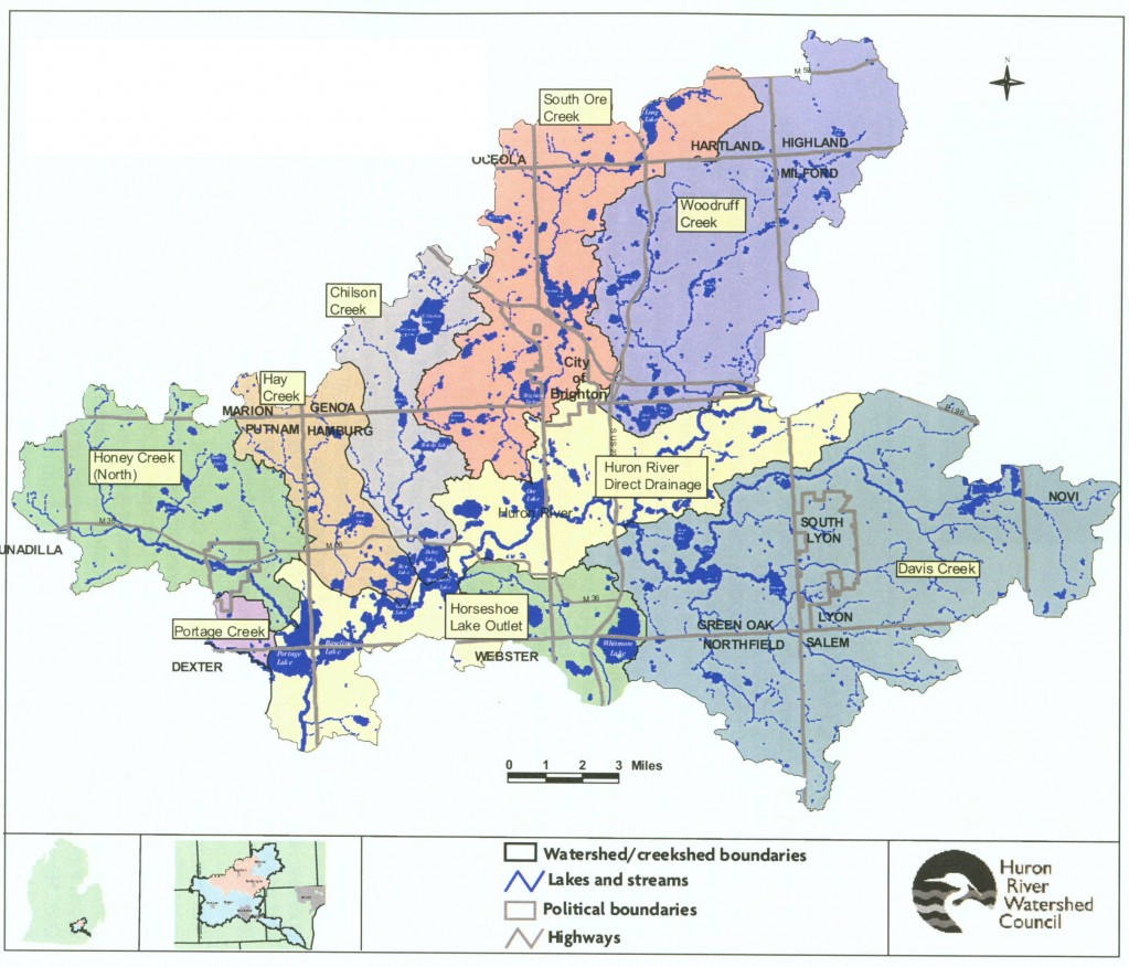
The Huron Chain of Lakes Watershed (a subwatershed of the Huron River Watershed) covers 253 square miles and drains an area from just below the Kent Lake Lake dam in Oakland County to just below Portage Lake in Washtenaw County. All or portions of 20 local communities are situated in the Huron Chain of Lakes Watershed. Within this area, the Huron River flows southwest for 27 miles through a series of wetland complexes and large glacial kettle lakes. Eight major tributaries and numerous smaller streams provide an estimated 593 miles of streams, which comprise the eight “creeksheds” in the Huron Chain of Lakes Watershed.
The Huron Chain of Lakes Watershed Management Plan is part of an effort undertaken by the communities of Huron Chain of Lakes Watershed to satisfy the requirements of the National Pollutant Discharge Elimination System (NPDES) Phase II Stormwater Permit (Michigan Watershed-Based General Permit MIG619000). The purpose of the Plan is to identify and execute the actions needed to resolve water quality and water quantity concerns by fostering cooperation among the various public and private entities in the watershed. While compliance with the NPDES Phase II permitting process is the Plan’s primary and mandatory function, the authors intend for the Plan to fit into a broader context of watershed management planning by laying the groundwork for a comprehensive, long-term effort to restore and protect the Watershed’s water resources for future generations. Further information can be found in the Phase II Stormwater Regulations section of the HRWC Non-Point Source Pollution webpage.
The Huron River Watershed Council was commissioned to facilitate the development of, and author, the Huron Chain of Lakes Watershed Management Plan. Following a two year development process, the Plan was submitted to the MDEQ for review in November 2005.
The following eight communities and county agencies comprise the core members of the Huron Chain of Lakes Steering Committee, which are responsible for the Plan’s development.
- City of Brighton
- Brighton Township
- Genoa Township
- Green Oak Township
- Livingston County Drain Commissioner
- Livingston County Road Commission
- Village of Pinckney
- Putnam Township
Several other communities and agencies located in the watershed, as well as individual residents, also participated in the development of this Plan.
Three primary challenges for the Huron Chain of Lakes are identified in the Plan:
- High nutrient (phosphorus) loading
- Altered hydrology
- Sedimentation and soil erosion
Sources and causes of these top challenges and several other challenges are described in the Plan, which form the basis for ten goals and objectives. A list of several actions, or Best Management Practices, are presented for meeting these goals and objectives.


