


What is a Watershed?
A watershed – also called a drainage basin – is the area of surrounding land that drains into a body of water such as a creek, river, or lake.
A watershed embodies all the life-sustaining connections and interconnections needed for clean water. First among these is the fundamental and inseparable connection between water and land.
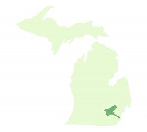
A watershed can be as small as a few acres draining into a farm pond, or as large as several thousand square miles for a major river system, such as the Mississippi, or a large inland lake, like Lake Erie. The Huron River drains into Lake Erie, so all of the land in the Huron River watershed is also part the Lake Erie watershed, which is part of the Great Lakes watershed.
A classic river watershed has creeks and streams that drain into the river in a pattern similar to the veins of a leaf. Each creek, or vein, has its own small watershed. Collectively, these creeks merge as they drain into the river, forming the river’s larger watershed. Whether small, medium or large, all watersheds share similarities of form and function, yet each one is ecologically unique.
From the core connection between water and land, other complex relationships emerge between and among animals and plants and their habitats, the habitats and the human residents, humans and the environment, and humans and their communities. The ecology of each watershed embraces all of these relationships, and, like all relationships, some are healthy, and some are not. 
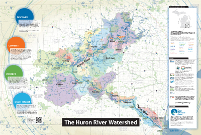
The Huron River Watershed
In southeastern Michigan, the Huron River watershed spans a land area of more than 900 square miles and drains water to the Huron River through hundreds of tributary creeks and streams. The river itself flows more than 125 miles from its headwaters at Big Lake, near Pontiac, to its mouth at Lake Erie. About 1200 miles of creeks and streams flow into the Huron’s main branch. The river’s drainage area includes seven Michigan counties (Oakland, Livingston, Ingham, Jackson, Washtenaw, Wayne, Monroe) and 68 municipal governments, serving six hundred and fifty thousand residents. The spectrum of land use and water environments ranges across remote natural preserves, cultivated farmland, urban and industrial centers, suburban sprawl, and an equal diversity of lakes, ponds, wetlands, creeks, and streams.

Learn more about the ancestral land where you live, work, and study
The Native Land Digital website has a wonderful mapping tool where you can zoom in and get names, links, and information, such as language and treaties, for the native nations and areas you select.
For a special fisheries report by The Michigan Department of Natural Resources check out this assessment of the Huron River Watershed (1995).