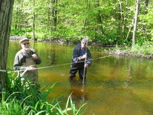
Last week, I had the opportunity to attend a three day training seminar given by the United States Geological Survey (USGS) in taking accurate stream flow and discharge measurements. The USGS takes measurements at sites across the country, but does not have the staff to measure every creek and river. By utilizing outside help, they have the possibility to greatly enhance their data.
This data is more important in Michigan now that we have a new water withdrawal assessment tool as a result of the Great Lakes Compact.
The water withdrawal assessment tool is “ a unique, internet-based system that enables users to easily determine the impact of a specific water withdrawal on a nearby stream. Michigan developed the tool to meet its obligations under the Great Lakes Compact, which protects rivers, lakes and groundwater from large new water withdrawals. According to new information from MDNRE, 216 withdrawals were processed in the first year under the new screening tool. Of those, 80% (172) were automatically authorized by the tool, meaning that no adverse resource impact was determined. The remaining 20% (44) were subject to further site specific reviews. Upon review, only 3 were determined to cause adverse resource impacts to streams, and were rejected. ‘This screening tool has significantly improved oversight of surface and groundwater withdrawals in Michigan and provides users with a fast, simple process to assess the impacts of their proposed withdrawal,” said Marc Smith, senior policy manager for the National Wildlife Federation. ‘The rejection of damaging withdrawals that would otherwise have proceeded proves that the tool is successfully protecting the most vulnerable fish habitat from harm.’” Quoted from a Natural Wildlife Federation press release this week.
However, the water withdrawal assessment tool is based on accurate stream flow and discharge measurements, a fairly sparse data set. Most of Michigan’s streams and creeks remain unmeasured and there is simply not enough money for federal and state agencies to ground-truth the model across the state. By gaining flow measurements on new streams, the creators of the tool will be able to improve its accuracy and improve its ability to determine if a proposed water withdrawal will have an adverse impact on the life of the river. That is where river and lake conservation groups, like HRWC, can lend a hand.
As HRWC already is monitoring our streams on a regular basis, we are well positioned to follow USGS flow procedures so we can generate data usable in our own work and that will help the State as a whole. Our data will provide for a more accurate model, further protecting our clean water supplies.


